430-year-old bizarre world atlas features Siberian Unicorns, merman, giant flying monsters and more
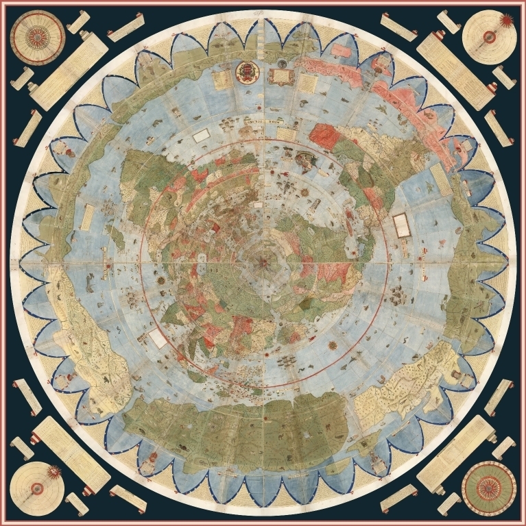
The map depicts the Earth as seen from space, when directly looking down at the North Pole.


A massive, colourful map of the world that was drawn up around 430 years ago has recently been restored and digitally stitched together, revealing the world as it was understood at the time. Researchers put together 60 individual pages of the 16<sup>th century world atlas, which features fantastical creatures such as Siberain unicorns, ship-attacking mermen, terrifying giant birds, large enough to snatch elephants with its talons.
The hand-drawn, 10 feet by 10 feet map from 1587, was created by a little-known cartographer Urbano Monte. National Geography reported that Monte was from a well-connected, wealthy family in Milan and had a keen interest in geography. Monte reportedly met with a Japanese delegation visiting Milan in 1585. His map, likely as a result of this meeting, contains numerous names within Japan, which don't appear on other Western maps created at the time.
According to collector David Rumsey, who bought the ancient atlas and donated it to the David Rumsey Map Center at Stanford University, which he founded in 2016, Renaissance mapmakers didn't like "empty spaces" CBC reported.
"There were many places that they did not know the names of towns and locations, so they filled them up with trees, monsters. They just used it as a palette, and it's so artistic and interesting that it just, it grabs us today," Rumsey reportedly said.
"It's unique in many ways," G. Salim Mohammed, the head and curator of the David Rumsey Map Center at Stanford University said, National Geographic reported. "No one has really studied this because it's been hidden for centuries."
Monte reportedly created his map 18 years after Gerardus Mercator created the map that is used today in most classrooms and smartphone apps, CBC reported. However, Monte's map, unlike Mercator's shows the Earth as seen from space, directly above the North Pole. Mercator's projection has recently reportedly been criticised for its Eurocentric depiction, which features the western and northern regions as bigger than they are.
"I think Monte was really trying to show the circular nature of the Earth," Rumsey said. "It's more than just a map," he said. "It's a whole scientific instrument."
The individual sheets and composite of the fantastical map are now online. Click here to view them.


