Underwater drones being used to detect enemy submarines, piracy and illegal fishing [Video]

Amid concerns mounting over Russia's military actions in Syria and rising global fears about the possibility of another Cold War, US military officials in the Pentagon are dedicating their efforts to make sure Russian submarines do not try to cut the essential undersea internet cables that countries, governments and citizens.
US intelligence officials report that they have seen significantly increased numbers of Russian vessels in the North Sea, north-east Asia and also in waters close to the American shores, particularly along the known routes of the undersea internet cables, according to the New York Times.
In one incident, Russian spy ship Yantar, armed with two self-propelled deep-sea submersible craft, was detected cruising off the East Coast of the US in September, which is close to where one of the internet cables lands near the American naval station at Guantanamo Bay.
The US Navy and Army are using spy satellites, ships and planes to monitor the situation but it is still concerned that Russian submarines could still manage to reach the seafloor miles below the surface and cut crucial cables with no one the wiser; other nations are worried too.
How do you patrol huge oceans effectively?
The ocean is a wide place and it is not always easy to detect nefarious activity or even find a missing plane, so what can the US and other countries do to improve their ability to monitor the high seas?
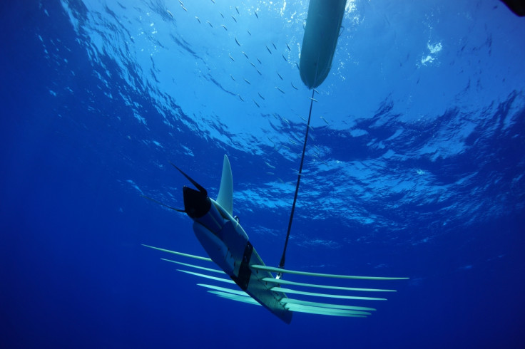
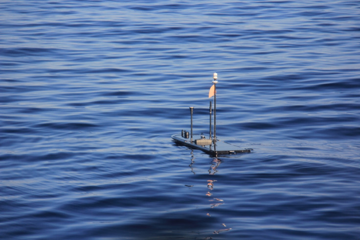
The answer is underwater drones, such as the Wave Glider technology utilised by Liquid Robotics. The drone comes in two parts – the Wave Glider sits on the surface of the sea, while the Wave Engine can go deep underwater – and it sends information wirelessly via satellite back to the cloud in real time.
Liquid Robotics is a US-based firm founded in 2007 and launched its first drones in 2010. In just five years, the firm has set a Guinness World Record for the longest journey of an unmanned autonomous surface vehicle and was awarded the Economist's inaugural ocean innovation award in June.
"Typically, countries fly over or drop a sonar buoy into the ocean to detect submarines. It's very expensive and it's like hunting for a needle in a haystack. At a hundredth of the cost, we can have a fleet of Wave Gliders detecting submarine incursions using acoustic sensors. We've offering an augmented way to detect submarines for defence of the country," Liquid Robotics president and CEO Gary Gysin told IBTimes UK.
According to Gysin, the cheapest vessel a country could use to patrol its oceans would cost $15,000 (£9,800) a day to operate, while deep ocean exploration would cost upwards of $500,000 a day. In contrast, it costs between $3,000 to $5,000 a day to run a Wave Glider; the price goes down the deeper the drone goes into the ocean.
"Countries don't necessarily have a large navy fleet or large air force to patrol their seas for illegal fishing, piracy and refugees. In order to patrol the seas with a manned asset, the bigger the ship, the more fuel it needs, and the deeper you go, the more expensive it is," Gysin said.
"With a robotics solution, we can detect [submarines and vessels associated with piracy] and then you send the more expensive asset out to go and intercept it, like another ship or an aircraft. So you're using the expensive target to go inner deck on something that's a known target, rather than just patrolling, which is quite expensive."
Using drones to detect piracy and earthquakes

According to Yahoo News, the Wave Glider is being used in classified missions for the Pentagon. However, Liquid Robotics could only confirm it is working with the US Navy and the Royal Australian Navy on defence missions but that it is not privy to what those missions are.
Several governments are interested in the solution, and the company is in talks with the Indonesian government to provide Wave Gliders to deal with illegal fish poaching, which is a huge problem in south-east Asia.
And while defence is one of the biggest markets for the Wave Glider, the technology is also being increasingly used to provide more accurate weather information for the National Oceanography Centre in Southampton, UK, as well as the US National Weather Service during potentially hazardous weather events, such as an incoming typhoon or hurricane.
"Even when ships and planes have to go back to shore for safety, we can continuously transmit information 24/7 from the drone even in the eye of the hurricane and grab information that's not possible to gain right from the surface of the ocean," Gysin said.

"We've been through 17 hurricanes, typhoons and cyclones, been in 70ft seas, 170 knot winds and we've been right through the middle of many cat 4, cat 5 hurricanes. We're good at predicting the path of a hurricane or typhoon, but not so much the intensity, so is it cat 2, 3 or 4? Should you evacuate? That's the science part that needs a lot of work."
The technology is also being used by scientists at the Scripps Institute of Oceanography to track the movements of tectonic plates in order to improve tsunami early warning systems, with the long-term aim of building a large network of sensors across the mid-ocean ridge of underwater mountains that wrap around the globe.
"There is no other ocean robot in existence that collects data, that moves in the ocean all the time, anywhere. The ocean is so important to us and there's a gap, that's a key problem we're solving that has not been solved today," Gysin said.
"We're providing info that you can't get today because it's too expensive or there's bad weather. Most companies rely on satellites for weather info before you commence a shipping operation. A satellite is far away and it uses models to predict what is happening, whereas we're actually in the water getting actual results."
© Copyright IBTimes 2025. All rights reserved.


