Axe Murders, Atlantis and Stranded Gemma Sheridan: Top Google Street View Hoaxes

Two mischievous men from Scotland sparked a major police investigation after playing a prank on Google Street View, having seen the camera car approaching last summer.
Dan Thomson, 56, and Gary Kerr, 31, staged a fake axe murder, with Thomson posing as the victim and Kerr the killer.
The pair had forgotten about the prank, however, until police turned up investigating reports of Thomson's death.
Kerr said: "I had seen various stunts that people pulled on Street View in the paper so we thought this was our chance. It was all Dan's thinking. He was the mastermind."
Hoaxes using Google Street View and Google Earth, which uses satellite imagery rather than camera cars, are plentiful after the launch of the service in 2007 and 2005 respectively. IBTimes UK looks at some of the best fake stories that emerged as a result.
Gemma Sheridan – Stranded on Desert Island
Gemma Sheridan was reportedly rescued after being stranded on a desert island earlier this year. She was found after an SOS sign was spotted by a boy from Minnesota Google Earth – the picture was retweeted hundreds of thousands of times.
However, it later emerged a freak storm that left her stranded never happened, and she did not survive by drinking rainwater and killing a goat. Instead it was a prank by some of her friends: "The people behind the website are just good friends with a strange sense of humour and busy brain," she told the Liverpool Echo.
"They posted the story then messaged me saying they were going to make me famous. I thought the story was a good one and it made me laugh."
The image used was originally from the city of Osh in southern Kyrgyzstan following violent events in 2010.
Thumbelina - Half Cat

In May last year, an image appeared on Google Street View showing a half cat. The white feline had a head, two front legs and a tail and left the internet in widespread confusion, with many speculating on its origin.
The cat was dubbed the Bipedal Half-Cat and was described as a "strange and beautiful" creature.
However, the cat, from Ottawa, Canada, turned out to be a completely normal creature with four legs and a full body – the image, not originally taken by Google Street View – had been photoshopped by someone on Imgur using two pictures merged together.
Reddit users were also quick to declare the creature a hoax: "I literally felt my corpus callosum stop functioning after looking at this picture. That's how old this picture is," one said.
Woman Gives Birth on Street View
She didn't. In 2010, the internet was awash with stories about a British woman giving birth on a pavement – and being captured by Google Street View. It was covered by publications including the Telegraph, the Independent and the Daily Mail.
The unnamed woman, apparently pictured in the Berlin suburb of Wilmersdorf, is seen lying on her back while two women help with the deliver – one is holding the newborn up in her hands.
However, the image was quickly declared a hoax by Google, with a spokeswoman saying it was "fake" and that the picture is "nothing like it appeared in Street View, someone just photo edited it".
It is thought the image was created by a group of German artists, although no one has come forward to claim responsibility.
Murder in the Netherlands

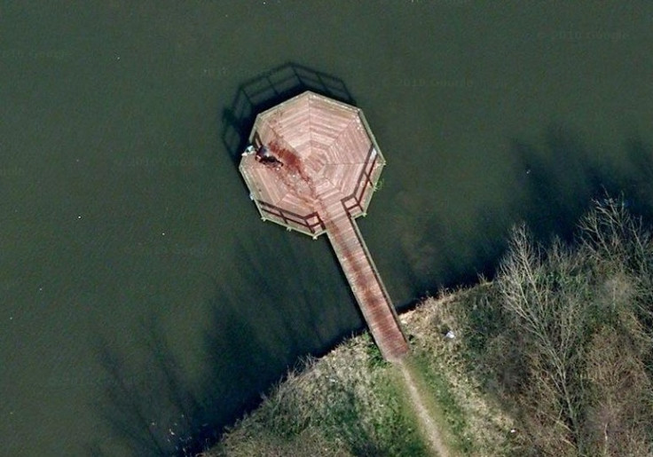
Last year an image began circulating on Reddit that appeared to show the scene of a brutal and bloody murder in Almere, just across the water from Amsterdam in the Netherlands.
The 'blood trail' was spotted on a jetty and trailed into the nearby park – the reddit user had called the post 'A murder near my house on Google Maps'. It was though the shadowy figure at the end of the jetty was preparing to throw the body into the water.
However, the murder turned out to be a wet dog called Rama who had been swimming. Rama's owner told the Sun: "When I saw the picture I realised, 'it's my dog'. He loves the water. He jumps off the end of the jetty, swims around to the bridge and runs down to the edge again. It's hilarious that everyone thought it was murder. But it's great he's now world famous."
Atlantis discovered
In 2009 it was reported that the legendary underwater city of Atlantis had been discovered on Google Earth, with satellite images at the coordinates 31 15'15.53N 24 15'30.53W showing a perfect rectangle about the size of Wales. An aeronautical engineer said the grid looked like an aerial map of a city.
It soon emerged that the lost city had not been discovered, however. Instead, Google announced it was sonar data that had been collected as boats mapped the ocean floor.
A spokeswoman said: "It's true that many amazing discoveries have been made in Google Earth including a pristine forest in Mozambique that is home to previously unknown species and the remains of an Ancient Roman villa.
"In this case, however, what users are seeing is an artefact of the data collection process.
"Bathymetric (or sea floor terrain) data is often collected from boats using sonar to take measurements of the sea floor. The lines reflect the path of the boat as it gathers the data."
© Copyright IBTimes 2025. All rights reserved.


