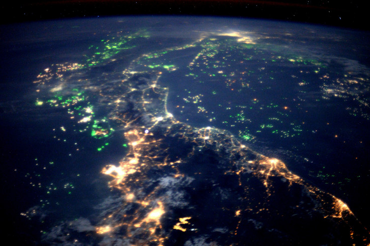
After finishing his 186-day Principia mission on board the International Space Station, British astronaut Tim Peake has put together a photo book that takes readers on a mesmerising tour of the Earth from above.
The Gulf of Thailand looking north over Malaysia towards Bangkok at top, with Kuala Lumpur on the left. All the dots of light in the sea are fishing boatsESA/NASA
From aerial photos of cities at night to the Northern Lights, the forthcoming Hello, Is This Planet Earth? My View From The International Space Station book features more than 150 of Peake's photographs that were taken from the International Space Station (ISS), many of which have never been seen before, along with a personal commentary by Peake himself. The book's title is inspired by the time in 2015 that he accidentally mis-called a woman from the ISS and asked her: 'Hello, is this planet Earth?'
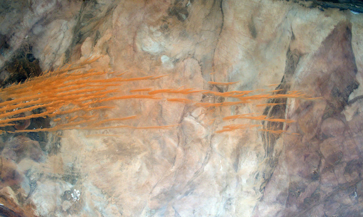
Chegga, Tiris Zemmour Region, Mauritania. The orange stripes are linear sand dunes in the Erg Iguidi desert that stretch from Algeria to northern Mauritania in the SaharaESA/NASA
Speaking about the book, Peake said that "It's impossible to look down on Earth from space and not be mesmerised by the fragile beauty of our planet. During my mission, I became determined to share this unique perspective of the one place we all call 'home'. This book captures a journey of discovery, not just the discovery of planet Earth – a stunning oasis of life in the vastness of space – but also the discovery of a newfound passion for photography, which has had a major impact on me."
IBTimesUK presents some of the best photos featured within Tim Peake's book, which is released on 17 November. All the proceeds received from the book will be donated to The Prince's Trust.
Ubar, OmanESA/NASAThe South Coast of the UK. The Isle of Wight is England’s largest island, home to more than 140,000 people. The heathland of the New Forest is also clearly visible to the left of the busy port of SouthamptonESA/NASALondon, EnglandESA/NASAThe United Kingdom under an auroraESA/NASALondon at night. The River Thames flows through the centre, with many of London’s famous bridges visible. The Isle of Dogs and Thames Barrier can also be seen. The central dark regions mark London’s royal parks, with Richmond Park to the lower leftESA/NASAThe city of Brest, FranceESA/NASAThe DIWATA-1, the first Filipino microsatellite is launched over the North Atlantic Ocean. This 50kg microsatellite was developed by scientists in the Philippines and Japan to provide satellite images for environmental monitoring and meteorological applicationsESA/NASAMoonlight reflected in the ISS solar panels as an aurora dances over Calgary, CanadaESA/NASAIn Patagonia, a magnificent swirling plankton bloom off the coast of Argentina. The swirling turquoise is caused by a massive gathering of phytoplankton, a microscopic plant that floats near the sunlit surface of the oceanESA/NASAAldabra Islands, the SeychellesESA/NASAJammu and Kashmir, India. The Zanskar Range is part of the Himalayas. The settlement at right is Padum, the only town in ZanskarESA/NASAIllizi, Algeria: a dune field in the Sahara Desert crossed by the border of Algeria and TunisiaESA/NASATunisia, Africa looking south-east towards LibyaESA/NASADubai, United Arab Emirates: Palm Jebel Ali on the left, next to the deep-water port of Jebel Ali. Palm Jumeirah and the World Islands can be seen on the rightESA/NASADamxung, Tibet, China. The sunlight reflects incredible colours off Lake Nam CoESA/NASAPierre, South DakotaESA/NASAAn iceberg in the South Atlantic OceanESA/NASASpacewalkESA/NASA