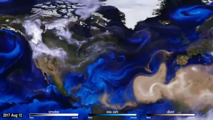
Stunning Nasa visualisation shows the devastating paths hurricanes Harvey, Irma, Jose took
The new simulation was created by the Goddard Earth Observing System in an attempt to further understand atmospheric changes.

This past year has witnessed some of the most destructive hurricanes in recent history, with Harvey inundating Houston, Ophelia triggering heavy rains in Europe and Puerto Rico suffering major losses thanks to Maria. Now, Nasa has created a visualisation that depicts the paths of these phenomena by tracking the aerosol particles that get carried through the atmosphere.
Given they are invisible, identifying changing atmospheric currents is a challenge and has to be tracked through the movement of tiny aerosol particles of smoke, sea salt, and dust that gets picked up along the way.
With the help of supercomputers, advanced physics and and a state-of-the-art climate algorithm known as FV3 provided by the Goddard Earth Observing System, scientists have been able to create a visualisation of the various hurricanes in 2017 and their trajectory between 1 August and 1 November.
The video offers a simulation of the movement of sea salt (in blue), smoke (in grey) and dust (in brown) as they make their way across large areas.
The blue animation shows how hurricanes Harvey, Irma, Jose and Maria grew from the Atlantic before making their way through parts of the Americas.
Smoke from the wildfires in Canada and parts of the US can be identified as making its way toward the east, while dust from the Saharan region follows a westward path across the Atlantic Ocean to the Gulf of Mexico. Dust from Africa and smoke from Portugal's wildfires can also be seen making their way across the UK and Ireland, carried forward by Hurricane Ophelia.
Our atmosphere as art! Enjoy this visualization created from NASA data that represents tiny particles such as smoke, dust, & sea salt as they are transported across the globe, making sweepingly beautiful visible weather patterns. pic.twitter.com/X3xfAYwqGY
— NASA Goddard Images (@NASAGoddardPix) November 16, 2017


